A selection of our current research and development is described below. Most of these projects are published or prepared to being published. Feel free to contact us if you want to know more about our research or are interested in a collaboration with us.
---
The Search Model explained
Going deeper than anyone else, that is what Ruden Water does. Ruden Water’s mission is to find fresh groundwater, at depths where only a few dare to explore. Ruden Water is currently assessing the potential for deep groundwater in Somalia, by utilizing data and techniques from the oil and gas industry, with promising outlooks. But how does this work?
As per 2020, not a single drop of water from ultra-deep coastal nor submarine aquifers is featured in the world’s statistics of strategic water reserves. Between 2005-2014, Ruden Water explored and identified a large submarine aquifer in Tanzania, the Kimbiji aquifer, containing 5000 km3 of freshwater, enough water for 1 million people for a period of 3000 years, solely with the aid of old oil exploration data.
We have established a systematic process for the exploration of deep groundwater prospects; the Search Model for Deep Groundwater along Passive Margins. The innovation lies in the combination of data acquired during oil exploration surveys and drilling technology from the oil industry, with applied hydrogeology.
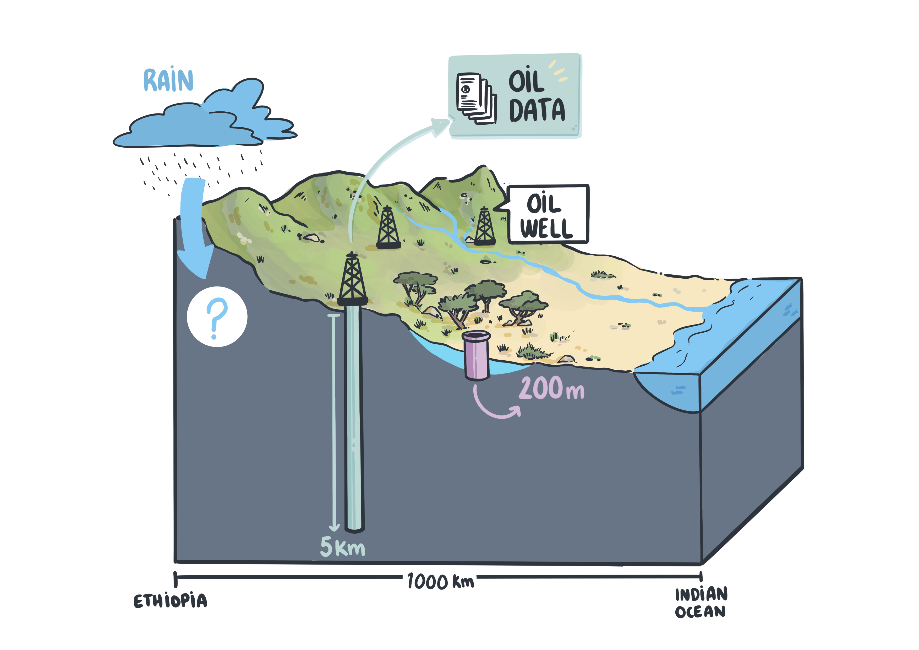
The Oil and Gas industry has spent billions of dollars on exploration for hydrocarbons around the globe. A big part of the exploration phase is gathering information about hydrocarbon prospects by acquiring seismic surveys to image the subsurface, and perform extensive analysis of the wells that are drilled to get detailed information on the fluids and geology. All of this information is sensitive as it is one of the companies most valued assets, and therefore hold tight to the chest or sold for millions.
But this information is not only valuable for the Oil and Gas industry. For the water industry it is very important to start venturing deeper to find new and undistubed fresh water resources. The information form the Oil and Gas industry can help with this.
With the access to well and seismic data from the Oil & Gas industry, it is possible to create 3D geological models that og deeper than 400m. This enables the visualization of potential deep aquifer systems and the modeling of deep hydrological systems.
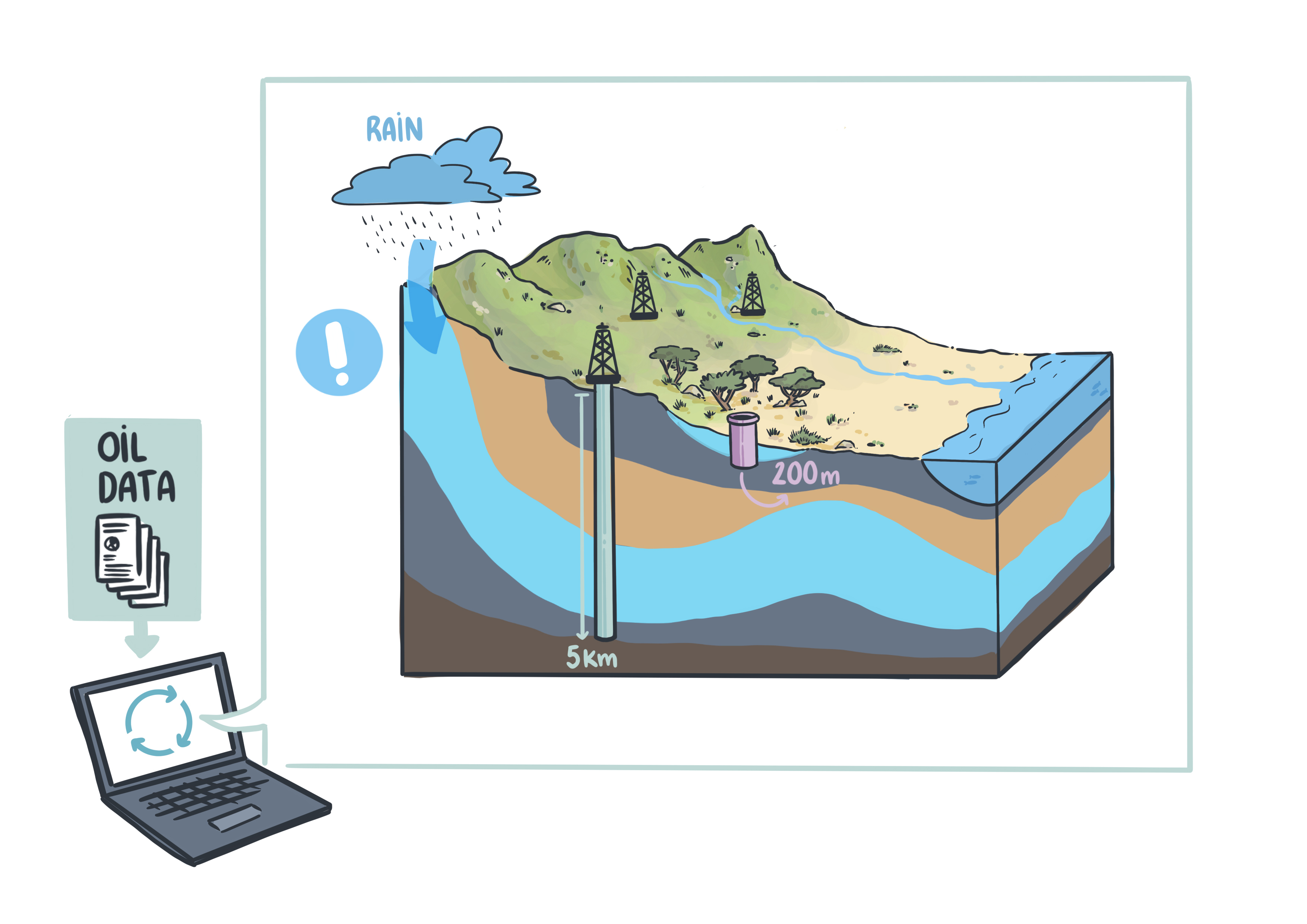
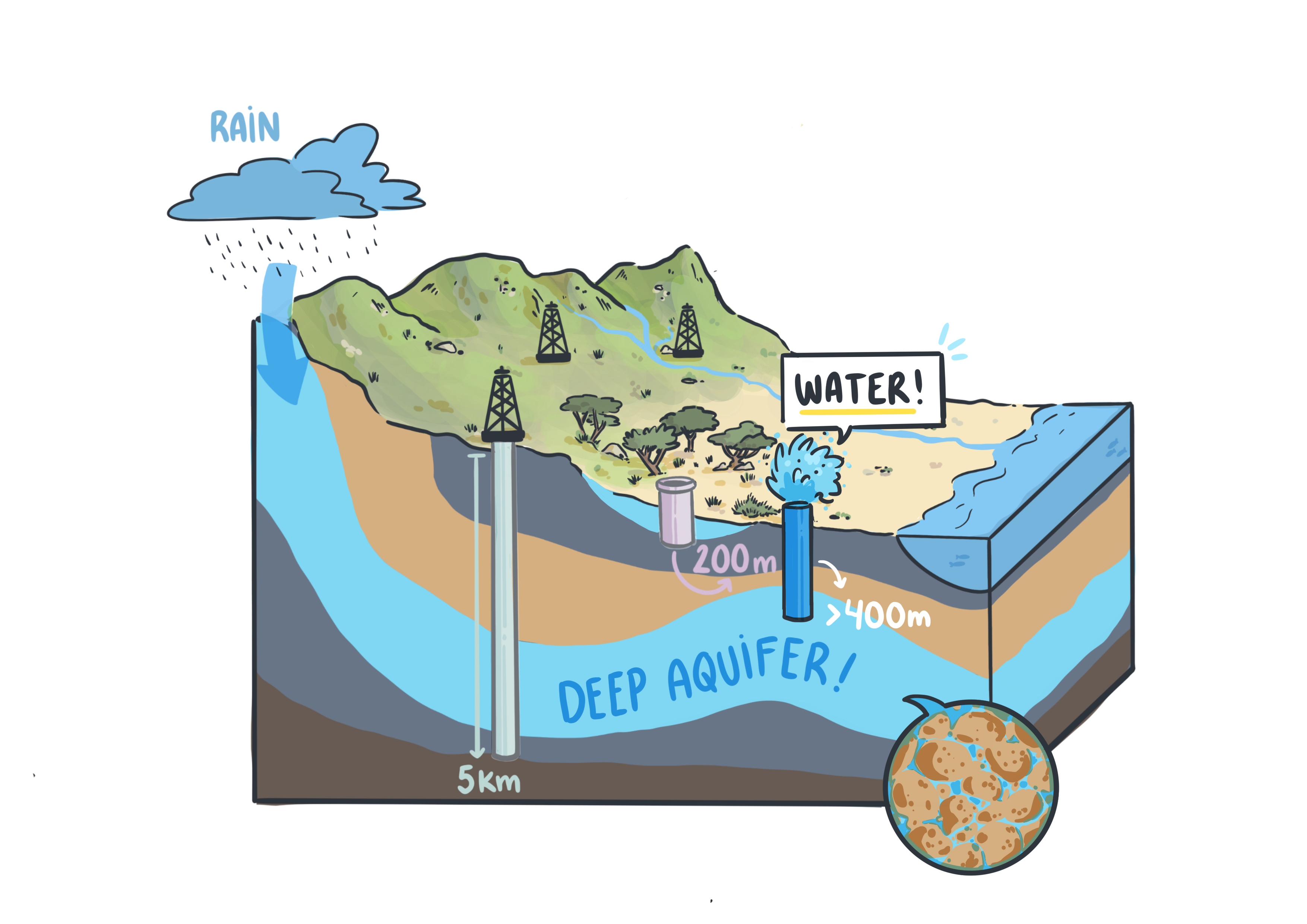
Modeling the deeper subsurfaces enables to make a model of the subsurface to a depth of a couple of kilometers, much deeper than traditional hydrology. This model can be used to find prospective areas for deep groundwater, at depths more than 400m, and the drilling of successful water wells.
Water in the sursurface is residuing in spaces between the grains of the rocks or in fractures, depending on the type of geology.
Our endeavors are no doubt a significant contribution towards a global awareness of these prospects. Data already acquired in the search for hydrocarbons can now be repurposed to find deep groundwater and provide a new source of revenue and purpose for the oil & gas industry.
The potential application of the Search Model not only includes developing countries, but also first world countries relying on desalination as a freshwater source. The use of existing oil data together with hydrogeological knowledge allows for quick and thorough assessments of the potential of deep groundwater without having to set up costly and time-consuming exploration projects. Recycling existing data lowers the cost of potential groundwater wells. Deep groundwater is a cost-effective solution for countries or regions that rely on non-secure water sources and has a lower cost compared to current desalination.
The Search Model identifies deep aquifers along passive margins and is applicable to similar settings around the world. Potential markets are Australia, Iraq, Kenya, Yemen, South Africa, South-East Asia and North America to name a few.
Deep low-salinity groundwater in sedimentary basins: petrophysical methods from a case study in Somalia
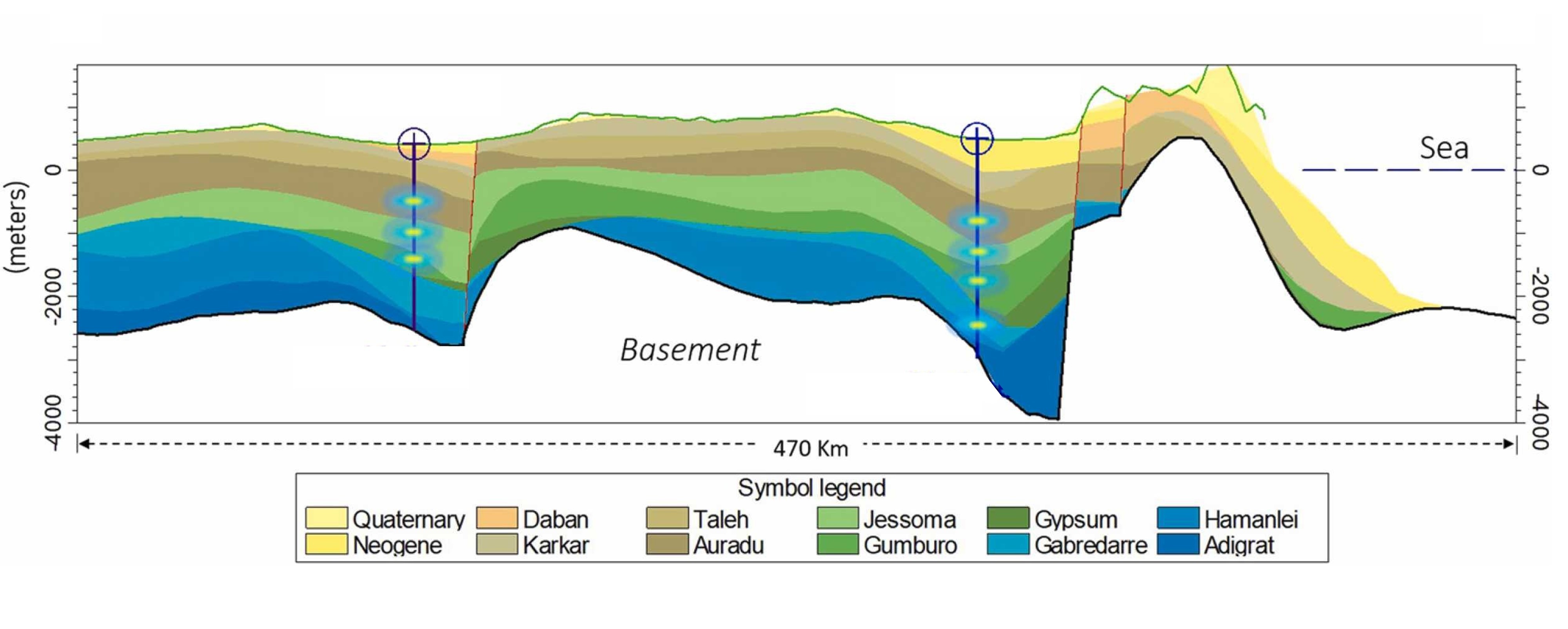
We investigated deep aquifer distribution in the northern part of the Somali peninsula using petrophysical techniques that have traditionally been applied to hydrocarbon exploration. An innovative methodology that has seldom been used for fresh groundwater analysis combines open hole measurements of resistivity, gamma rays, spontaneous potential, as well as mud logging and drill stem tests. This approach allows identifying previously unknown deep freshwater ( < 5000 ppm salinity) aquifers within the Jurassic to Eocene stratigraphic units, including the Adigrat, Hamanlei, Gabredarre, Gumburo, Jessoma and Auradu formations, and paves the way for mapping deep regional aquifers.
For more details, find the article here.
A 3D geological model of the Horn of Africa, as the basis for hydrogeological simulations of deep groundwater systems
This study demonstrates how a 3D geological model may be defined in extensive and logistically difficult areas of the East African regions affected by water scarcity, fully based on available and open access data. It also lays the path for additional regional hydrogeological research where an interdisciplinary strategy might provide fresh data to models' inputs and enhance calibration. The new 3D geological model of the Horn of Africa shows the full extent of a series of units that potentially host deep aquifers in the region. Aquifer characteristics including porosity, permeability, and pressure were appropriately transferred from the hydrocarbon context to the hydrogeology context. The results from this study can be used to build a complete hydrogeological model of the region.
Due to the deeper reach compared to conventional hydrogeological data (geophysical and wells); it is important to emphasize that oil and gas exploration data is irreplaceable for identifying deep aquifers. Based on freshwater indications, six regional units were identified as potential aquifers: Adigrat, Hamanlei, Gabredarre, Gumburo, Jessoma, Auradu. Of these units, while the most recent and shallowest, i.e., Auradu and Jessoma (Cretaceous to Paleocene) have been previously recognized as regional or local aquifers, the oldest ones, i.e., Adigrat, Hamanlei, Gabredarre and Gumburo (Jurassic to Cretaceous) are here reported for the first time as potential deep aquifers.
For more details, find the article here.
Mapping karst in the Horn Africa
Karst refers to a particular type of landscape that is formed over a period of thousands of years due to dissolution of rocks in mildly acidic rain. Karstification can dramatically change the original landscape and this has consequences on the magnitude of groundwater recharge. Underground caves and tunnels are sub-surface characteristics of karst. Subsurface karst further complicates the path that water takes into subsequent layers of the earth, in addition to characteristics of the surrounding porous medium, fractures and faults.
We are in the process of mapping karst over the Horn of Africa in an effort to better understand the geomorphology of the region and to predict areas of high groundwater recharge potential.
Groundwater recharge in the Horn of Africa
Groundwater recharge is the part of rainfall that gets absorbed into the surface of the earth.
Recharge = Rainfall – Evapotranspiration – Runoff
Evapotranspiration is the amount of water that is returned to the atmosphere from surfaces (soil, lakes, leaves, plant roots, etc). Runoff is the part of water that flows over the land and may join rivers and streams. We seek to answer what the groundwater recharge distribution looks like for the Horn of Africa, and to understand where does this water go using 3 D geological simulations using ModFlow and MRST.
Groundwater recharge in the light of climate change
Most of the water that is found today deep into the surface of the earth below the Horn of Africa is probably from the end of the last ice age. Will there every be such a recharge event going to be into the future in face of global warming?
Statistical distributions of rainfall and runoff
We seek to answer the following questions:
- Can statistical distributions of rainfall, runoff, evapotranspiration and recharge over the Horn of Africa help you predict the future climate variability?
- What does the distribution of rainfall, runoff and groundwater recharge look like for major hydrological basins of the Horn of Africa?
- How does the boundary of a hydrological basin change with time?


